PortAll, a web application dedicated to port management and navigation
PortAll is a web application dedicated to port services. It is organised into modules adapted to the different professions (each using only the modules that are useful to them): hydrographers, harbour masters, ushers, pilots and boatmen, etc.
How can you support and facilitate the work of the various port functions with a single solution?
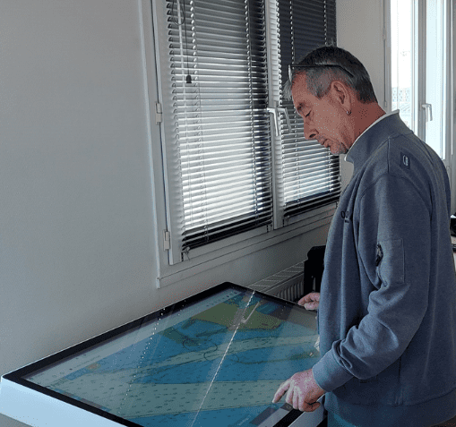
PortAll is a simple, intuitive application using the latest web technologies. It can be used both from a large-format touch screen and from a smartphone.
Feel free to explore PortAll's features!
Use the online demo to find out more about the tool:
🗒️ Add and create notes, notices and obstructions
📐 Create and position templates
🧭 Draw and plan navigation routes
Easy to learn, with no obligation: your data is not stored and will be automatically deleted after 7 days.

A tool dedicated to the port's various trades
For the Hydrographer
The ULHYSSES module enables the hydrographer to automatically produce and update bathymetric coverage as soon as a new sound file is available. It is produced in the form of a bENC (S-57 standardised bathymetric ENC). As soon as the hydrographer has validated the result, all authorised* PortAll users can view the updated navigation plan. Pilots can also download the bENCs for their PPUs (Portable Pilot Units). ULHYSSES can be supplemented by other modules: Notices (positioning of symbols, contacts, photos, etc.) and Obstructions (reporting obstructions). The added information appears immediately to users authorised to view these layers of information.
* Harbour master's office, pilots (provided they have subscribed to the service)
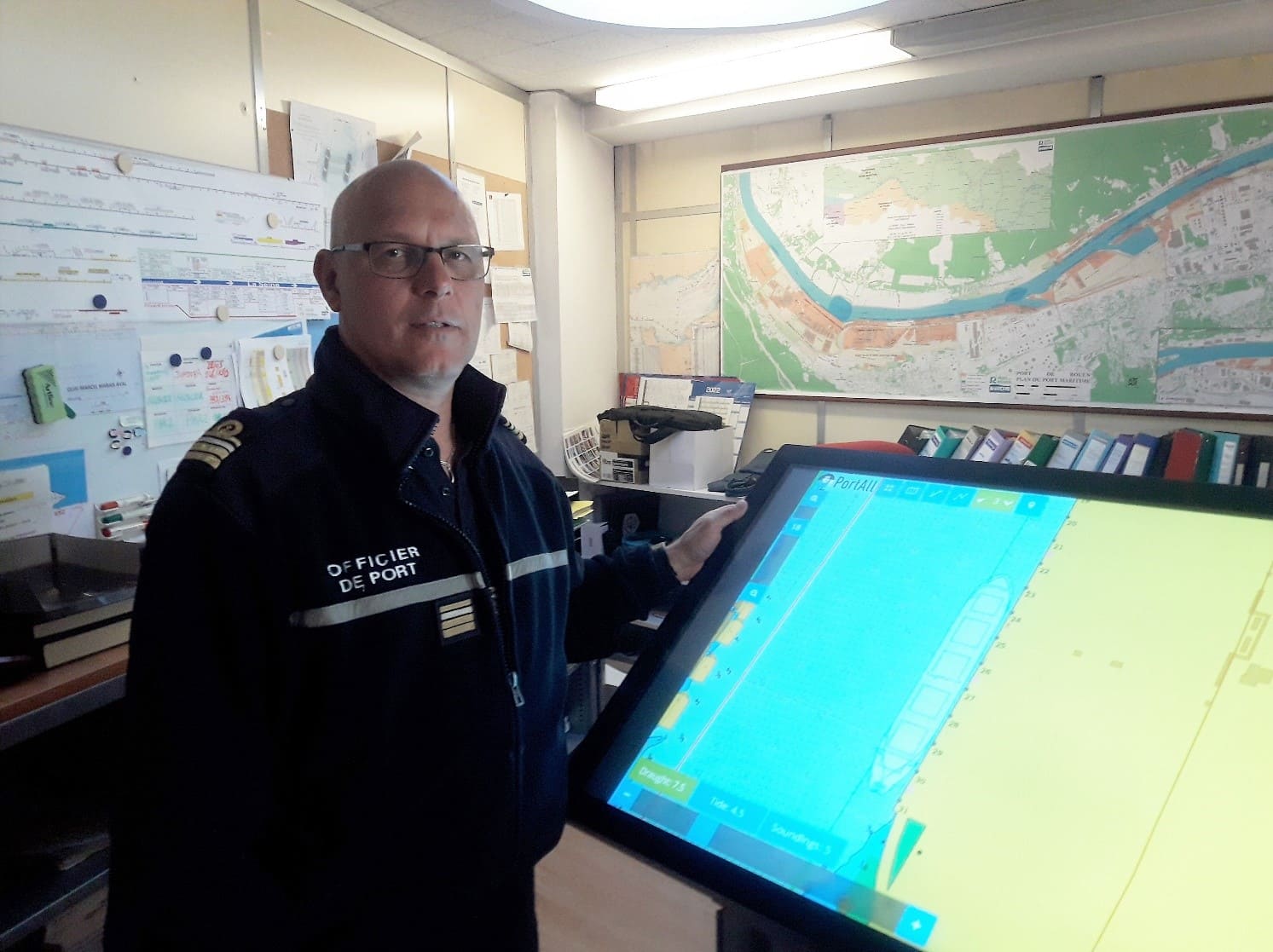
For the Harbour Master's Office
In addition to the quay map supplied during configuration, a high-precision S-57 standardised port map can be ordered. Combined with the ULHYSSES module, the Ship Placement module enables you to manage ship placement reliably and accurately
The captain can move customisable templates and integrate mooring points, connection points or any other useful information for optimised service. It features the standard S-52 display with Day, Twilight and Night palettes for optimum viewing on lookout. Several modules are integrated into the Harbour Master option: AIS (display of data in real time: cranes, anemometers, tide gauges, etc.), Mariners Note (addition of annotations), Obstructions (as well as any other shared data (obstructions, quotations, etc.), Measurement (measurement of distances), Notices (positioning of symbols, contacts, photos, etc.) and Replay (display of the last manoeuvres).
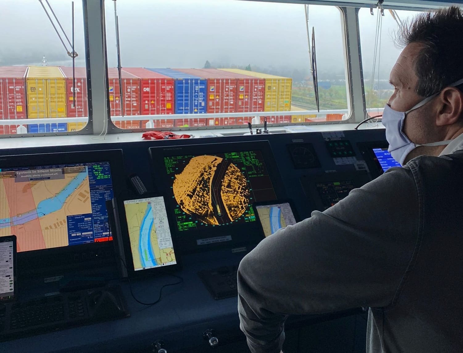
For the pilot
PortAll provides pilots with all the information they need to prepare for missions. They can receive notifications when a vessel is approaching, entering or leaving its allocated mooring zone. With their smartphone or minitablet in their pocket, pilots can get on board with all the most accurate and up-to-date data (port charts, bathymetry, quotations, notes and notices, obstructions) as well as realtime data (AIS, anemometers, tide gauges, etc.).
PortAll is also the tool for communication with the ship's captain and offers several services to the pilot, including the Passage Plan module (predefinition of the passage plan), Replay (display of the last manoeuvres), Notifications (notifications on the smartphone), Measurement (measurement of distances) and Mariners Notes (addition of annotations) and Notices (positioning of symbols, contacts, photos, etc.).
PortAll Base - Basic package
View high-precision S57 nautical charts and port maps.
Complementary modules to meet specific business requirements (Hydrographers, Harbour Master's Offices and Pilots).
Use of the most accurate and up-to-date data (bathymetry, ratings, notes and notices, obstructions) as well as real-time data (AIS, anemometers, tide gauges, etc.).
Training to get to grips with the tool.
STANDARD / PREMIUM user support.
Creation of high-precision S-57 standard port charts
Using the port's topographical data, Geomod can produce standardised port charts to order (customisable according to your needs: addition of bollards, cranes, buoys, fenders and other objects useful to pilots but generally not represented on nautical charts).
Additional services available on request.
The application at the service of Harbour management and navigation.
• Display of real-time data
• Vessel guided to the Harbour entrance by pilot boats
• Display of the vessel's travel since 1h... 6h
• Definition of several guard zones around the vessel
• Estimation of the time of arrival at a given point using the ETA (Estimated Time of Arrival) function
• Possibility to save the past hours of real time in order to replay the record later
• Generation of a vassel's Template using its real dimensions, orientation and placement
• Considerable gains in terms of time and precision
• PortAll allows to optimize the use of harbour infrastructures
They trust us :
• Haropa Port - Le Havre Rouen Paris
• Service du pilotage Marseille-Fos
• Pilotage maritime de Dunkerque - 1583
• Pilotes maritimes Sete - Sete Port, Safe Port
Simplicity, Efficiency and Real-Time Data : A time saver and a guarantee of security for everyone.
To find out more and discover the tool features, contact us : portall@geomod.fr
Hello, Nabila Bounoua, I'm a geomatics engineer. I joined Geomod four years ago.
Can you describe your job?
I work with the Brest team on the development of a solution called PortAll. My main task is to work with users and customers to better understand their needs, which I then pass on to our development teams. In particular, I'm responsible for PortAll training, technical support and the production of port maps.
Can you tell us about the PortAll tool?
PortAll is a web application designed specifically for port management and navigation. It's a solution that facilitates and assists the work of the various port professions.
Who is PortAll designed for?
Our platform is modular and specifically tailored to the requirements of each maritime profession, such as hydrographers, harbourmasters, pilots and boatmen. We already work with a number of major French ports and pilot stations, including GPMM, the Grand Port Maritime de Marseille.
What are the strengths of the PortAll tool?
PortAll enables highly accurate, real-time data to be shared between the various departments. Its strength lies in its ability to automatically update bathymetry on a highly accurate map base, which not only saves time but also enhances port safety.