Calhypso, a solution for cartographic and hydrographic services
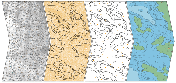
One of main tasks of cartographers is processing bathymetric data to convert it into navigational charts (or ENCs). The cartographic synthesis of water depth data is a painstaking and time-consuming task, and is affected by a concern for uniformity and accuracy. Calhypso, the result of a project designed to address these issues, is a software package that processes bathymetric files and produces ENCs automatically.
Calhypso presentation video
A tool able to convert a xyz bathymetric dataset into a generalized S57 nautical chart in a few minutes !
A partnership between Geomod and Shom.
Geomod :
• Cartography
• Generalization
• ENC
• High Density Data
• Scale
• Precision
• Safety navigation
• Reproducibility
• Efficiency
• Readability
XYZ Survey :
• Compilation scale
• Depth contour values
• Generalization parameters
Parameters :
• Data decimation
• Sounding selection
• Insoline simplification and smoothing
S57 bathymetric chart can be opened with ENC editors.
In addition :
• Time saving
• Reproducibility
• Adjustable precision
• Validation tool assistant
• Update tool assistant
A complete tool designed for marine cartographers
Ask us for your free demo and for more informations, contact us at : calhypso@geomod.fr
The service dedicated to cartographic and hydrographic services
Creation of ENC charts
Creation of generalised bathymetric charts from high density bathymetric data (.xyz; .lgz; .glz; .pts; .csar files).
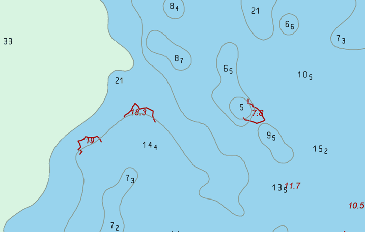
Control of the sounding selection to ensure that the result meets the security and legibility requirements of cartographers.
High-quality generalisation frees the cartographer from repetitive tasks and makes it easier to analyse complex cases.
Detection of new dangers to navigation
Comparison of new bathymetric data with an existing ENC to identify discrepancies and warn mariners of new hazards.
Updating ENC from new survey dataset
DEPARE geometries creation and sounding selection to update ENC inside the data extent.
Merging new ENC geometries with old ones.
Chart ajustments applied near the data boundary to get a uniform update result.
How do you produce and update bathymetric navigation charts?
A service dedicated to hydrographic and cartographic solutions for producing and updating bathymetric navigation charts. Calhypso includes validation tools in addition to its main ENC creation functionality. In this way, the software helps to control and update charts using the most recent bathymetric surveys.
• XYZ input dataset : 1 000 000 depth points
• Optional S57 context dataset : land areas and dangers
• Welcome to Calhypso Web
• Input files
• Parameters
• Output file name
• Start process
• Processing time : 1min 36sec
• Output : standardised S57 .000 file
• A safe and readable paper navigation map
• Adjustable generalisation of depth contours
• Safe and uniform sounding selection
To try Calhypso Web, contact us at calhypso@geomod.fr
An automated tool able to compare a new survey dataset (.xyz, .lgz, .glz, .csar) with a reference ENC catalog.
Step 1 : Import xyz dataset
Step 2 : Specify ENC directory
Step 3 : Add optional filterings and launch process
Step 4 : 2 ENC intersect the survey, the comparison wtith the first ENC is achieved, the comparison wtith the second ENC is achieved
Step 5 : Output results
Step 6 : 2 intersected ENC, Calhypso Detect sorts deviations into 3 severity files
Calhypso Detect highlights every data sounding with a significant gap from reference ENC as defined by B-620 section of S-4 IHO standard.
Calhypso Detect identifies soundings to add and isoline sections to update.
Calhypso Detect can process high-density datasets in few minutes.
Contact us to test Calhypso Detect at calhypso@geomod.fr
A software developed by Geomod by Coexya and the Shom.
What makes CALHYPSO revolutionary?
- Production of S-57 bathymetric ENCs in a matter of minutes, including the generalisation of isolines and the selection of soundings
- Optimised algorithm capable of processing an unlimited volume of data
- Safe navigation rules
- And a new feature: quickly create your ENC from a set of localised data
A project developed from the combined expertise of GEOMOD and SHOM.