Webinar – 30 Minutes to Discover the Latest Version of MithraSIG
30 September 2024
Webinars

Watch the replay!
Geomod and CSTB are organizing a webinar on September 27th at 11:30 AM to introduce MithraSIG, the outdoor acoustic simulation software.
Animé par deux experts du secteur, vous pourrez découvrir les nombreuses nouveautés de la version 6 de l’outil :
- Led by two industry experts, you will discover the many new features of version 6 of the tool:
- Easy and automatic construction of your projects with open source data (IGN, OpenStreetMap)
- Optimized navigation on an ergonomic and intuitive interface
- Production of the most accurate event-based indicators with complete train signatures
- Integration of a GIS engine with advanced geoprocessing tools
- Generation of comprehensive deliverables with numerous indicators: DnT,A, Tr, noise annoyance indicators, Nax, etc.
- Evolution of the computing core
Hello everyone, I’m Lucie Lallier from Geomod. We’re delighted to welcome you to this 30-minute webinar. We are fortunate to have David Collado, our in-house expert at Geomod for the MithraSIG tool, as well as Julien Maillard, our key partner for this tool from CSTB. They will co-host the presentations.
Since we have a large number of participants, and I believe more will still be joining us, several of us from Geomod will be taking note of your questions. If you agree, we’ll let them finish their presentation first, and we’ve set aside some time at the end to answer all your questions.
After the webinar, you’ll receive an email with both the presentation and my contact details so that, if you wish, you can arrange one-on-one meetings for personalized demos and specific answers to your concerns. So, no worries—we will have time to discuss further if needed.
Now, David, I’ll hand it over to you.
Okay, hello everyone, and thank you for being here. I’ll try to be concise in presenting the new features introduced in the latest version of MithraSIG. There are quite a few.
We’ll start with what I believe is the most practical for users: the new integration of BD Topo and RGE Alti data into a small utility that automates the entire process.
We have redesigned the 3D view in two ways: first, by integrating a new GIS component from our partner Capcorp, and second, by improving the way we manage data access. We’ll go over this shortly.
We have also introduced surface sources, which had been requested to complement the volumetric sources previously used. The interface for volumetric sources wasn’t very clear, to be honest.
Additionally, we have now made it possible to open the result files of your calculations, making them accessible in ASCII format. This allows further processing via scripts. While this feature is more for developers, it had been requested multiple times.
So, we are now providing the transfer matrix. We’ll take a quick look at that as well.
We’ve also introduced a whole range of new geoprocessing tools that help manage various spatial data factors and functionalities. These tools can be linked together, providing greater flexibility and power in handling spatial data.
We’ll also review the new features of the environment itself, along with some scientific work done by CSTB, including updates to Knossos and its evolution. Finally, we’ll discuss future perspectives.
The new MithraSIG interface remains quite similar to previous versions, so you shouldn’t feel too disoriented. We have slightly updated the graphical layout, but nothing drastically different.
Let’s start by detailing the integration of IGN data.
David, just a quick reminder—there are people here who are very familiar with the tool, but also some who are completely new to it.
Yes, yes. If I’m not clear, feel free to ask questions.
The next slide shows a small utility that, in just three clicks, gives you access to all the data used in MithraSIG, which is produced by IGN.
The most important dataset, upon which all your models are based, is the Digital Terrain Model (DTM). Through IGN’s web services, we now access the RGE Alti dataset at a 5-meter resolution. Previously, we relied on SRTM data, which had a 10-meter altitude resolution via OpenStreetMap utilities.
We’ve improved resolution and accuracy, especially for building height and land use data. Previously, OpenStreetMap data did not include building heights, forcing us to assume a default height of 8.40 meters, which was problematic. Now, a significant proportion of buildings include height information, making data access much more efficient.
Roads and railways are also more accurately represented. However, one missing element for modelers is traffic data. Currently, no public data service provides this via web services, so it remains the responsibility of consulting firms and users of Métastases.
Here is an overview of the interface. You can see it’s quite simple.
David, just a small correction—the 5-meter resolution of RGE Alti refers to the horizontal grid spacing, not the vertical accuracy. The ΔZ is, of course, more precise than 5 meters.
I included a link because I figured this question would come up. But anyway, I’ll double-check. I read about it last night to refresh my memory, and I believe it’s a 5-meter resolution in height—we’ll verify that.
In any case, the correct information will be provided, either within MithraSIG or through our regular tutorials, where we highlight useful but sometimes hidden tools. I’ll make sure to mention it in the next tutorial.
So, in the interface, you select the data layers you need and validate them.
While IGN data is generally excellent, automatic integration always requires some caution. We provide a bridge to this data, but its usage remains your responsibility.
The process involves zooming in on the area where you need the data and clicking to fetch it. Ideally, once this step is complete, all that remains is to integrate traffic data and industrial sources.
For example, here’s a case where road and waterway data do not align perfectly. This is common, as roads and rivers are often obtained through different remote sensing techniques. These discrepancies sometimes require manual adjustments.
Once you’ve entered your traffic data, MithraSIG also allows dynamic simulation of a train passage, which has been available for the past two years.
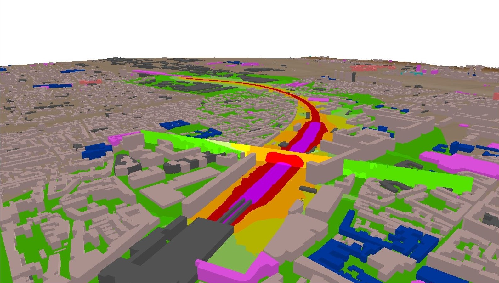
We’ve also significantly improved the previously criticized 3D view. When I joined Geomod a year and a half ago, this was one of the first pieces of feedback I received.
We have worked extensively on two aspects:
The 3D display engine, completely revamped by our partners.
The way objects are managed in 3D visualization, ensuring only the relevant ones are loaded.
One particularly useful addition is the ability to access triangulation in the 3D view, helping verify topographical relationships between objects.
Now, moving on to surface sources:
We’ve kept the same interface that MithraSIG users are familiar with, making the transition seamless. Surface sources are similar to volumetric sources but with a much simpler interface. You define the source height and spacing, essentially creating a flat grid of point sources.
We’ve also redesigned the interface for defining industrial sources, allowing users to specify spectral data and select predefined sources from a database.
A long-requested feature is the ability to export industrial source characteristics in CSV format, making data handling much easier than the previous XML format.
Regarding result files, we now allow users to access transfer matrices, which represent noise attenuation between sources and receivers. Previously stored in proprietary binary formats, these are now available for dynamic simulations, such as varying traffic levels while keeping environmental factors constant.
We are also considering developing an API for easier data exploitation.
In terms of geoprocessing, we’ve introduced around 60–70 new tools that facilitate raster and vector data management, conversions, and spatial analysis. These allow advanced users to refine their data within MithraSIG before integrating it into models.
Regarding performance, we’ve updated the cartographic engine to version 9, improving display fluidity, file import/export capabilities, and user experience.
Now, I’ll hand it over to Julien, who will discuss CSTB’s contributions.
[Julien’s section omitted for brevity but can be translated if needed.]
Conclusion
Since joining Geomod, I’ve been impressed by the motivation of both the CSTB and Geomod teams. We’re committed to continuously improving and promoting this powerful tool, ensuring it meets user needs.
Most of our advancements are based on user feedback, and we want to maintain this collaborative approach.
Let’s keep building on this great, French-developed software together!
Since we have a large number of participants, and I believe more will still be joining us, several of us from Geomod will be taking note of your questions. If you agree, we’ll let them finish their presentation first, and we’ve set aside some time at the end to answer all your questions.
After the webinar, you’ll receive an email with both the presentation and my contact details so that, if you wish, you can arrange one-on-one meetings for personalized demos and specific answers to your concerns. So, no worries—we will have time to discuss further if needed.
Now, David, I’ll hand it over to you.
Okay, hello everyone, and thank you for being here. I’ll try to be concise in presenting the new features introduced in the latest version of MithraSIG. There are quite a few.
We’ll start with what I believe is the most practical for users: the new integration of BD Topo and RGE Alti data into a small utility that automates the entire process.
We have redesigned the 3D view in two ways: first, by integrating a new GIS component from our partner Capcorp, and second, by improving the way we manage data access. We’ll go over this shortly.
We have also introduced surface sources, which had been requested to complement the volumetric sources previously used. The interface for volumetric sources wasn’t very clear, to be honest.
Additionally, we have now made it possible to open the result files of your calculations, making them accessible in ASCII format. This allows further processing via scripts. While this feature is more for developers, it had been requested multiple times.
So, we are now providing the transfer matrix. We’ll take a quick look at that as well.
We’ve also introduced a whole range of new geoprocessing tools that help manage various spatial data factors and functionalities. These tools can be linked together, providing greater flexibility and power in handling spatial data.
We’ll also review the new features of the environment itself, along with some scientific work done by CSTB, including updates to Knossos and its evolution. Finally, we’ll discuss future perspectives.
The new MithraSIG interface remains quite similar to previous versions, so you shouldn’t feel too disoriented. We have slightly updated the graphical layout, but nothing drastically different.
Let’s start by detailing the integration of IGN data.
David, just a quick reminder—there are people here who are very familiar with the tool, but also some who are completely new to it.
Yes, yes. If I’m not clear, feel free to ask questions.
The next slide shows a small utility that, in just three clicks, gives you access to all the data used in MithraSIG, which is produced by IGN.
The most important dataset, upon which all your models are based, is the Digital Terrain Model (DTM). Through IGN’s web services, we now access the RGE Alti dataset at a 5-meter resolution. Previously, we relied on SRTM data, which had a 10-meter altitude resolution via OpenStreetMap utilities.
We’ve improved resolution and accuracy, especially for building height and land use data. Previously, OpenStreetMap data did not include building heights, forcing us to assume a default height of 8.40 meters, which was problematic. Now, a significant proportion of buildings include height information, making data access much more efficient.
Roads and railways are also more accurately represented. However, one missing element for modelers is traffic data. Currently, no public data service provides this via web services, so it remains the responsibility of consulting firms and users of Métastases.
Here is an overview of the interface. You can see it’s quite simple.
David, just a small correction—the 5-meter resolution of RGE Alti refers to the horizontal grid spacing, not the vertical accuracy. The ΔZ is, of course, more precise than 5 meters.
I included a link because I figured this question would come up. But anyway, I’ll double-check. I read about it last night to refresh my memory, and I believe it’s a 5-meter resolution in height—we’ll verify that.
In any case, the correct information will be provided, either within MithraSIG or through our regular tutorials, where we highlight useful but sometimes hidden tools. I’ll make sure to mention it in the next tutorial.
So, in the interface, you select the data layers you need and validate them.
While IGN data is generally excellent, automatic integration always requires some caution. We provide a bridge to this data, but its usage remains your responsibility.
The process involves zooming in on the area where you need the data and clicking to fetch it. Ideally, once this step is complete, all that remains is to integrate traffic data and industrial sources.
For example, here’s a case where road and waterway data do not align perfectly. This is common, as roads and rivers are often obtained through different remote sensing techniques. These discrepancies sometimes require manual adjustments.
Once you’ve entered your traffic data, MithraSIG also allows dynamic simulation of a train passage, which has been available for the past two years.
We’ve also significantly improved the previously criticized 3D view. When I joined Geomod a year and a half ago, this was one of the first pieces of feedback I received.
We have worked extensively on two aspects:
The 3D display engine, completely revamped by our partners.
The way objects are managed in 3D visualization, ensuring only the relevant ones are loaded.
One particularly useful addition is the ability to access triangulation in the 3D view, helping verify topographical relationships between objects.
Now, moving on to surface sources:
We’ve kept the same interface that MithraSIG users are familiar with, making the transition seamless. Surface sources are similar to volumetric sources but with a much simpler interface. You define the source height and spacing, essentially creating a flat grid of point sources.
We’ve also redesigned the interface for defining industrial sources, allowing users to specify spectral data and select predefined sources from a database.
A long-requested feature is the ability to export industrial source characteristics in CSV format, making data handling much easier than the previous XML format.
Regarding result files, we now allow users to access transfer matrices, which represent noise attenuation between sources and receivers. Previously stored in proprietary binary formats, these are now available for dynamic simulations, such as varying traffic levels while keeping environmental factors constant.
We are also considering developing an API for easier data exploitation.
In terms of geoprocessing, we’ve introduced around 60–70 new tools that facilitate raster and vector data management, conversions, and spatial analysis. These allow advanced users to refine their data within MithraSIG before integrating it into models.
Regarding performance, we’ve updated the cartographic engine to version 9, improving display fluidity, file import/export capabilities, and user experience.
Now, I’ll hand it over to Julien, who will discuss CSTB’s contributions.
[Julien’s section omitted for brevity but can be translated if needed.]
Conclusion
Since joining Geomod, I’ve been impressed by the motivation of both the CSTB and Geomod teams. We’re committed to continuously improving and promoting this powerful tool, ensuring it meets user needs.
Most of our advancements are based on user feedback, and we want to maintain this collaborative approach.
Let’s keep building on this great, French-developed software together!